Point Pleasant Park sits at the southern tip of the Halifax peninsula. Comprising 185 acres of forest, trails, beaches, monuments, and military fortifications, the Park has a rich history and has been an important landmark for the region’s people. The site was traditionally a significant Mi'kmaq gathering place known as Amntu’kati (“spiritual place” or “the place of spirits”), then served as an important British defensive site, where numerous fortifications and batteries were constructed to guard the entrance to the harbour.
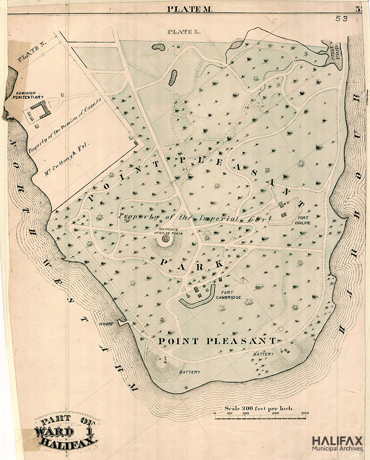
City Atlas of Halifax Nova Scotia ("Hopkins Atlas") Plate M, 1878. HMA CR10-004
Since 1873 the City has leased the park from the federal War Department (subsequently through the federal government's agency, Parks Canada) at the cost of 1 shilling per year. Beginning in the 1960s, an annual shilling ceremony was held to symbolize the renewal of this lease. The 20th century saw the transition of the park into the recreation and leisure destination it is today.
To commemorate the park and its place in Halifax’s history, the Municipal Archives provides this guide to records in our holdings relating to the City’s management and development of Point Pleasant Park. While we have attempted to make this guide as comprehensive as possible, it may not be an exhaustive listing of all relevant materials in our holdings. This guide will be added to as new materials are acquired and described.
Photographs

[Point Pleasant Park gates], [191-?]. HMA CR30E-1-Park Gates

[Prince of Wales Martello Tower], 1911. HMA CR30E-1-Martello

Lodge Point Pleasant, 1976. HMA CR30K-1-24.71

Martello Tower 1796, 1982. HMA CR30K-1-24.140

[Fort Ogilvie Cannon], [198-?]. HMA CR30K-1-24.9

[Black Rock Beach and South End Container Terminal], [198-?]. HMA CR30K-1-24.80

Halifax - Point Pleasant Park stand built 1881, 1956. HMA CR25-28

Point Pleasant Park [Black Rock Beach], [196-?]. HMA 102-39-1-1123.7

Point Pleasant Park [buildings - canteen], [1964] (cropped from original). HMA 102-39-1-1124.1

[Cambridge Battery], 1989. HMA 102-104-A-5.17

[Black Rock Beach], 1989. HMA 102-104-A-5.11

[Point Pleasant Park Trail], 1989. HMA 102-104-A-5.21

Point Pleasant and Container Pier, [1989]. HMA 102-104-A-5.20

Winter, 1989. HMA 102-104-A-5.23

Point Pleasant Park canteen [fire aftermath], [196-] (cropped from original). HMA 102-111-4-5.114

Pt. Pleasant [fountain], 1989. HMA CR40-23.21

Aerial view of Fort Ogilvie, 1943 (cropped from original). HMA CR63

[Soldier on Prince of Wales Tower], 1940. HMA CR56.7

[Aerial] Point Pleasant Park, [198-?]. HMA 102-104-A-5.1

[Point Pleasant battery in winter], [198-?]. HMA CR30K-1-24.21


The Municipal Archives holds many photographs depicting Point Pleasant Park, described in the following listing. Many images have been digitized and samples of them can be viewed in the above slide gallery, on our Flickr page, or in our online database.
Tourism Halifax photographs (series 102-104)
- 102-104-A-5 Point Pleasant Park, 1970-1996. Includes 22 photographs of Point Pleasant Park (digitized).
- 102-104-H-2 Beaches, 1970-1996. 9 photographs, including several of Black Rock Beach (not digitized).
Committee on Works - Works Department photographs (sub-series 102-39-1)
- 102-39-1-1123 Point Pleasant Park, [196-?]. 8 photographs showing various paths and spots throughout the park (digitized).
- 102-39-1-1124 Point Pleasant Park [buildings], [1964]. 4 photographs showing the outbuildings in the park, including the canteen, the Caretaker’s house, and the Superintendent’s office (digitized).
Halifax Fire Department - Fire scene photographs (sub-series 102-111-4-5)
- 102-111-4-5-10 Point Pleasant Park Canteen fire, [196-?]. 12 photographs (not digitized)
- 102-111-4-5.114 to 102-111-4-5.116 Point Pleasant Park Canteen [fire aftermath], [196-?]. 3 photographs (digitized)
Recreation Department photographs - Recreation facilities - Point Pleasant Park, 1973, 1977, [197-?] (102-106-1-1-147 to 102-106-1-1-149)
3 photographs of people enjoying Point Pleasant Park in winter (digitized).
Lou Collins fonds, 1879-2006 (CR30)
- [Harbour and Arm Views], Pam Collins photographs, 1965-1987 (CR30K-5-1). Images taken from and of Halifax Harbour, including views of they city skylines, the Halifax and Dartmouth sides of the harbour, container ports, wharves, oil refinery, naval piers, ships in the water, Point Pleasant Park (40 photographs, not yet digitized).
- Pam Collins photographs - Architecture - [Point Pleasant Park], 1975-1989 (CR30K-1-24). Images of various notable park features (150 photographs, 28 digitized).
- Postcards, 1905-[197-?] (CR30E-1). Postcards collected by Lou Collins depicting various local scenes and landmarks, including many of Point Pleasant Park (304 postcards, some digitized).
Ernie Reksten's business trip photographs of Halifax and Dartmouth - Halifax - Point Pleasant Park stand built 1881, 1956 (CR25-28)
Ernie Reksten was a travelling salesman and compulsive photographer who came to Halifax on a business trip in 1956 and photographed, among other things, the park’s gazebo/bandstand (30 photographs, digitized).
Graham Lavers fonds - Photography Teaching slides, 1988-1989 (CR40-23)
Graham Lavers was a professional photographer who often worked for the City of Halifax to document its landmarks and special events, and who also taught photography at community college. Among his teaching photographs are 4 photographs of the park (digitized).
Nola Stoddart WWII collection, 1940-1967 (CR56)
Nola Stoddart and her family collected many WWII-era mementoes, including photographs of Point Pleasant Park’s gates and the Prince of Wales Martello Tower. 3 photographs (digitized).
Major Lewis DeMone photos of Halifax, 1942-1984 (CR63)
This series includes several aerial photographs of military installations, including an overhead view of Fort Ogilvie in Point Pleasant Park.
Documents
Directors of Point Pleasant Park records, 1873, 1875, 1912-1996 (102-59)
The Point Pleasant Park Commission was the managing body for the park. Established in 1866, its directors had the power to make park regulations or by-laws, appoint gatekeepers, accept financial donations for the park, and hire the superintendent and other workers to improve the grounds, with the approval of the Halifax Royal Engineers. The responsibilities and power of the board changed little over its 130-year life. Following amalgamation in 1996, the board was reformed as the Point Pleasant Park Advisory Committee. Records in this series include correspondence and reports, minutes, and regulations.
- Agreement respecting the use of Point Pleasant Park, 1873, 1875, 1929 (102-59A.1) Commonly known as the Point Pleasant Park lease, this original agreement between the Crown (War Department) and Directors of Point Pleasant Park allowed use as public park. It was signed and sealed Dec. 31, 1873 by William Young, President and John Sinclair, Mayor and Vice-president of the Point Pleasant Park commission. The lease includes an attached annexed plan delineating boundaries of the park land. Archives file also has two copies of transcripts of the agreement, printed in 1929.
- Correspondence and Reports, 1973, 1875, 1912-1995 (102-59A) Includes correspondence of the Directors, 1912-1995, as well as reports, meeting minutes, financial documents, newspaper clippings, and other material. Also includes a plan and agreements relating to park usage, 1873-1875. There are also many detailed documents regarding changes to the Park and events such as the Shilling ceremony, including 6 shillings. Sub-series includes a file list for records 1873-1967, but files from 1967-1995 are not listed.
- Minutes, 1920-1996 (102-59B) Directors of Point Pleasant Park met on a variety of agenda items concerning the park including finances; maintenance of the grounds; the condition, maintenance, and repairs of forts and batteries and Martello tower; the annual shilling ceremony; the park lodge; and other park activities. Meeting minutes also include reports from various city and park staff and members of the board, as well as related newspaper clippings.
- Regulations, Direct of Point Pleasant Park records, [ca. 1972], 1982, 1995 (102-59C) This sub-series consists of one folder of park regulations, and pamphlets detailing the regulations.

Pamphlet of the Regulations Governing Point Pleasant Park, 1978. HMA 102-59C-1
City Manager’s Subject Files (102-4)
The City Manager kept files relating to executive-level planning and maintenance of Point Pleasant Park.
- Point Pleasant Park, 1978-1981 (102-4.01.330.15). Includes excerpts of city council minutes, minutes of the Directors of Point Pleasant Park meetings, and information reports, correspondence, and memos relating to Point Pleasant Park. Records cover a variety of topics including finances, board appointments, canteen operations, rules and regulations, and reports from the Directors of Point Pleasant Park and/or their Chairman. There are also records relating to a case of extreme vandalism which occurred in 1980.
- Point Pleasant Park, 1983 (102-4.01.330K). Includes a copy of a pamphlet outlining Point Pleasant Park regulations. This pamphlet is also in Regulations, Director of Point Pleasant Park records (102-59C).
- Point Pleasant Park, 1985 (102-4.1985.01.330K). Includes correspondence relating to a proposal for the Halifax Engineering and Works department to take over management of Point Pleasant Park, and a proposal for Parks and Grounds to maintain the park (as opposed to the Superintendent). Also contains a report from an engineering firm assessing the deterioration of the park gates (which also discusses the Public Gardens gates).
- Point Pleasant Park, 1986 (102-4.1986.01.330K). This file contains meeting minutes from the Directors of Point Pleasant Park and an information report on the appointment of a Chairman of the Directors. Also includes correspondence about the park, including correspondence and a report on the gatehouse.
- Point Pleasant Park, 1987 (102-4.1987.01.330K). Contains records relating to park maintenance, including correspondence relating to sewer lines, specifications, tender and architectural drawings on the restaurant building in the park, correspondence concerning the toilets in the park, and correspondence on park lodge.
- Point Pleasant Park, 1990 (102-4.1990.01.330K). These records largely relate to park maintenance, especially protection of forest and flora within the park. They include a report to the Board of Directors about park flora; various documents about the Forest Improvement Project, including a copy of “A Forest Management Strategy for Point Pleasant Park”; records from the Point Pleasant Park Technical Advisory Committee, including correspondence, memos, meeting minutes, status reports, a user study, and other research materials; correspondence about seawall repairs (also referred to as shore protection); and letters to the park superintendent from the Canadian Forestry Commission.
- Point Pleasant Park, 1992 (102-4.1992.01.330K). This file contains correspondence on financial matters, discussion of registering heritage properties in the park, and off-leash dogs.
- Point Pleasant Park, 1993 (102-4.1992.01.330K). This file contains requests and correspondence for the funding of a park user study.
- Point Pleasant Park, 1994 (102-4.1994.01.330K). This file contains documents on the maintenance of the park and its structures, including correspondence on the assessment of the Point Pleasant Park battery, the lease for Point Pleasant Park, and a determination of responsibility for maintenance of the fortifications. Also includes correspondence and meeting minutes concerning the Park’s heritage designation, including a report on the historical relationship of the park. There is also correspondence on hiring summer staff as well as correspondence, memos, reports, and meeting minutes on repair work for the lodge.
- Point Pleasant Park, 1995 (102-4.1995.01.330K). This file contains documents on the maintenance, staffing, and security of the park, including correspondence and select meeting minute items on updates to the park gates and harbor/lower parking lot. There are additional documents on park security, tendering for equipment, and correspondence on a sewer easement. Note: Parts of this file is restricted due to personnel information of park staff – ask an archivist for more details.
Planning Department reference files, 1959-1995 (102-105-3)
This sub-series within the Development and Planning Department records consists of reference files used by the department to assist in the planning, development, and redevelopment of various pieces of land throughout Halifax.
- Parks - Point Pleasant Park, 1982-1987 (102-105-3-Box15). Includes newspaper clippings from various publications and authors (including local historian Lou Collins) regarding the history and current events of the park, and a photocopied publication about the Prince of Wales Tower (author and publisher unknown).

Naval Memorial, [198?] (CR30K-1-24.63)
Mayor's Office records, 1922-1996 (series 102-3)
Series includes records created or collected by the Mayor’s Office, including correspondence, scrapbooks, and subject files. These files cover a wide range of topics; Point Pleasant Park may be referenced in other files. Researchers should also browse file lists for this series in the archives’ database.
- Point Pleasant Park Commission, 1932-1937 (102-3B-43)
- Point Pleasant Park Commission (T.E. Fripps, Supt.), 1938-1944 (102-3B-76)
- Point Pleasant Park Commission, 1992-1994 (102-3-5-019)
City Council minutes and submissions, 1841-1996 (series 102-1A and B)
Council minutes and submissions are an excellent source of information about decisions and development of municipal issues, including issues relating to Point Pleasant Park.
We recommend you start by searching the indexes to find relevant references, and then consult those minutes directly. Reports, correspondence and petitions mentioned in the minutes are not included in this digitized content; contact the Municipal Archives to obtain copies of these submissions.
Lou Collins records (CR30)
Local historian Lou Collins collected research and records on multiple historic sites and buildings in Halifax for general interest, academic work, and his advocacy for the preservation of local built heritage. Collins was also Halifax's Civic Historian, and a member of both the Landmarks Commission and the Heritage Advisory Committee.

Point Pleasant Gates, Dec. 1976 (CR30K-1-24.1)
- Heritage trust report on Point Pleasant Lodge, July-August 1990 (CR30I.133). This file consists of correspondence between Heritage Trust of Nova Scotia and the City’s Heritage Advisory Committee, and research related to the Point Pleasant Lodge. The research is compiled into an application to register the lodge as a Heritage Property, and covers the history of the park and lodge, its architectural importance, and background on architect J.C. Dumaresq. It also includes a basic bibliography and photographs which appear to be from the Pam Collins photography sub-series (CR30K-1-24).
Maps and Plans

Half Elevation of Gates for Point Pleasant Park, [1885]. HMA 102-39P-E-1-357
City of Halifax Engineering and Works maps and plans (102-39P)
The City Engineer's Office, later the Engineering and Works Department, was the central filing area for all maps or plans used by any City department. Among the thousands of drawings stored at the Archives include the following showing various aspects of Point Pleasant. Only a few have been digitized, but just put in a request and that can be done!
- A-3-78: Plan showing the difference between the original Town plot of the City of Halifax and the old surveys of the North West Arm Road and the Government lands at Point Pleasant Park. 1847.
- C-6-395: Plan showing design for iron gates for Point Pleasant Park. 1885
- E-1-357: Half Elevation of Gates for Point Pleasant Park, Edward Elliott architect. [1885]
- E-5-491: Plan of Point Pleasant Park. [Between 1870 and 1890]
- KK-1-8306: Copy of plan - part of Jason Mack & Miller Land's. (Point Pleasant Drive formerly known as Miller Street). 1893.
- O-4-3275: North West Arm sewer - Plan of sewer right-of-way from Jubilee to Black Rock. [Between 1900 and 1920].
- K-2-1213: Plan of Point Pleasant Park Showing Paths and Drain. 1900.
- F-9-1148: Plan of Peoples Heat & Light Co. property at North West Arm showing proposed roadways for Point Pleasant Park. 1900.
- Q-7-1844: Contract Plan - Design for Ferrymans Cottage - Point Pleasant Park. 1908.
- XX-17: [Copy of Map of Northwest Arm Area - Both Shores from Dutch Village to Point Pleasant Park/Past Jollimore- Showing Topographic Lines, Streets, Proposed Streets, Houses, Estates with name of Owner, High and Low Water Marks, Factories, Mills.] [191-?].
- X-11-4103: North West Arm Intercepting Sewer - Condensed Profile from Oakland to Chain Rock. [Between 1910 and 1930].
- S-9-2236: Plan of Point Pleasant Park & Steel’s Pond. 1910.
- Q-2-2350: Division of property near Point Pleasant Park. 1914.
- X-9-4035: North West Arm Sewer - Plan of proposed revision in Point Pleasant Park. 1917.
- AA-7-5249: Plan of subdivision of Charles Brister - Francklyn Terrace. 1920.
- ZZ-25: Plans- Elevation and Section of the Prince of Wales Tower Halifax 1812 - Point Pleasant Park. 1812; traced 1921.
- DD-7-5706: Plan of club house for Royal Nova Scotia Yacht Squadron - W.J. Busch architect. 1921.
- DD-7-5707: Amended plan of club house for Royal Nova Scotia Yacht Squadron - W.J. Busch architect. 1921.
- PP-2-11077: Dept. of Militia and Defence MD No. 6 Office of SEO Halifax - Point Pleasant Park plan showing roads. 1922.
- HH-6-7914: Dept. of National Defence plan of Point Pleasant Park [Shows surrounding properties and pathways within park]. 1922.
- DD-6-5627: Plan - Point Pleasant Park and vicinity. 1923.
- CC-7-6041: Extension of Tramway into Point Pleasant Park, via Tower Rd. 1927.
- CC-6-6058: Nova Scotia Tramways and Power Co. LTD - Proposed Tramways Extension into Point Pleasant Park. 1928.
- J-6-6091: Plan of proposed Extension to Martello Tower. 1928.
- KK-10-9155: Plan - Nova Scotia Tramways and Power Co. - Proposed track extension Martello Tower. 1928.
- BB-4-6687: Plan Miller Street proposed extension within Point Pleasant Park [Miller Street now known as Point Pleasant Drive]. 1931.
- GG-4-7817: Plan of soundings at Mouth of North West Arm and Point Pleasant. 1932.
- ZZ-26: Fort Ogilvie showing E.L.EMPL. - Department of National Defence traced from plan no. 48-24-20; shows roads and path, footprint of batteries, sewer and water lines, cable-lines in Point Pleasant Park. 1942
- LL-4-10017: Chain Rock showing 1943 soundings compared to 1918 soundings. Point Pleasant Park. [1943?].
- LL-2-9292: Profile - Chain Rock [Drive]. 1943.
- AA-3-4873A: Soundings at Chain Rock [Drive]. 1943.
- JJ-7-9434: Plan - drainage areas from Chebucto Roads to Point Pleasant Park. 1944.
- ZZ-15: Point pleasant park - shows paths, bench marks, ponds, gravel pits, boundary. [194-?]
- PP-1-11032: Addition to Keeper's Lodge - detail of buttress and cornice. J.P. Dumaresq, architect. Point Pleasant Park?, 1947-08-07
- NN-2-10552: Sketch - Proposed Gates at Point Pleasant Park. 1948.
- OO-2-11128: Plan - subdivision of property owned by H.B. Bell (McKenzie Plan). [Point Pleasant Drive formerly known as Miller Street]. 1949.
- PP-7-11497: Inglewood Subdivision - P.S.C. plan showing sewer and water right-of-way from Francklyn St. 1949.
- NN-6-10913: Profile - sewer on former Brister property - Inglewood Subdivision. [Between 1947 and 1952].
- OO-1-10901: Plan - Brister property - Inglewood Subdivision - Kendall plan. 1949.
- PP-5-11307: Heating plan keepers lodge Point Pleasant Park - first and second floor plans. [1950].
- OO-3-11415: Plan - Subdivision of Little Property (Point Pleasant Drive formerly Miller Street) by McKenzie. 1950.
- PP-4-11288: Plan keepers lodge addition Point Pleasant Park. 1950.
- QQ-2-11740: Francklyn Street showing proposed sewer outlet [Northwest Arm]. Sketch only - assessment plan. Shows Pine Hill Divinity College. 1951.
- QQ-3-11793: Plan showing land to be conveyed by the Dominion Government to the City of Halifax. [edge of Point Pleasant Park]. 1951.
- OO-3-11731: Inglewood Subdivision - Inglewood B, proposed subdivision McKenzie Plan. 1951.
- OO-4-11857: Plan - Inglewood subdivision, Section B by McKenzie. 1951.
- OO-4-11929: Plan - Inglewood "B" subdivision, original layout by McKenzie. 1951
- QQ-3-11742: Front Elevation - Workshop and Garage at Point Pleasant Park [Ellis Plan]. 1953.
- RR-1-12482: Dressing rooms bathing facilities Point Pleasant Park. 1953
- RR-1-12503: Plan and cross section profile showing elevations over mound and location of old fort with elevations at Point Pleasant Park. [Fort Ogilvie]. 1953.
- QQ-7-12471: Plan showing properties fronting on Inglewood Dr. and Balmoral Road for assessment purposes. [Plan shows names of house owners and North West Arm]. 1953.
- OO-6-12681: Plan - Re-subdivision of lots 11-13 Inglewood Subdivision by McKenzie. 1954.
- OO-8-13236: Plan - Re-subdivision lots 26 & 27 Inglewood "B" subdivision (McKenzie Plan). 1955.
- OO-8-13231: Plan - Re-subdivision of Lots 29 & 30 Inglewood "B" Subdivision (McKenzie Plan). 1955.
- RR-7-13748: Canadian Overseas Telecommunication Corporation. [Eleven plans of underground cables showing water mains over bridge, over railway lines and through Point Pleasant Park; nine plans showing cables along Sackville Street and South Park Street.]. [1955-1956].
- RR-7-13749: Canadian Overseas Telecommunications Corporation, Halifax N.S. Branch - Key plan cable landlines. [Shows peninsula area from MacDonald Bridge to Point Pleasant Park, and routing of telecom cables.]. [195-?].
- RR-5-13516: Point Pleasant Park - Plan showing location of road, poles, trees, etc., from Point Pleasant Drive to the Yacht Squadron. [Also shows parking area and footprint of canteen building.]. 1956.
- RR-7-13867: Point Pleasant Park - Black Rock - Plan showing area to be considered for possible site of toilet facilities. [Also shows water and sewer lines, contours of area, location of bath house, pathways, and general location of Royal Nova Scotia Yacht Squadron property.]. 1957.
- RR-6-13692: Plan of proposed parking area Point Pleasant Park Commission. 1957.
- SS-1-14001: Plan showing washroom and septic tank with details at Black Rock. [Shows plans for a washroom facility at Black Rock beach in Point Pleasant Park, adjacent to Royal Nova Scotia Yacht Squadron. Includes plot plan, various elevations and floor plans, septic system layout, and various other building details.] 1958.
- SS-1-14110: Plan showing location of proposed sewer on National Harbours Board property at Point Pleasant Park. [Includes two sheets, one showing site area, the other showing contours, embankments, gates to yacht squadron, etc. Sheet #1 traced from RR-7-13867, sheet #2 traced from FF-3-10326.] 1958.
- SS-2-14200: Plan and profile of sewer outlet at Point Pleasant Park. [Includes locations of bath house, embankments, washrooms, septic tank, and Royal Yacht Squadron.] 1958.
- OO-9-14911: Plan - Re-subdivision of lots 14 and 42 Inglewood Subdivision (McKenzie plan) P200/191. 1960.
- SS-6-15024: Plan showing Inglewood "B" subdivision and north end of Point Pleasant park. 1961.
- ZZ-28: Plan showing suggested Re-subdivision, Pt No. of Inglewood 'B' Subdivision; Planning Office drawing. No. P303-18. 1962.
- OO-9-15633: Plan - replotting lots 1, 2, 37 and portion of Chain Rock Drive of Inglewood "B" Subdivision. 1963.
- OO-9-16229: Plan - Francklyn Park Subdivision (Donovan plan) P200/1788. 1965.
- ZZ-27: Proposed Relocation of National Harbour Board Boundary at Ocean Terminal No. 8-HOT-107. [Shows Point Pleasant Park Canteen and maintenance shop.] 1972.
- ZZ-30: Point Pleasant Park Lower Entrance - drawings of features by School of Architecture. [197-?].
- TT-5-16551: Plan shewing position of water lots granted on Eastern shore of Northwest Arm. [Copy of 19th century plan showing titled lots from the Eastern Shore to Point Pleasant, with reference to volume and page number of lot grant. Fortifications at Point Pleasant, footprint of penitentiary, public landings at the bases of South Street, Studley and Jubilee Roads, and Horseshoe Island are visible.] Undated.
Halifax Harbour Commissioners plans - [Miller Street], 1929-1936 (CA 1.5)
- Ocean Terminals Miller Street Extension: Proposed Relocation of Point Pleasant Park Gates. August 29, 1930 (CA-1.5.1)
- Ocean Terminals Miller Street Extension: Proposed Relocation of Point Pleasant Park Gates. August 29, 1930 (CA-1.5.2)
Miscellaneous
- CR10-004 City Atlas of Halifax Nova Scotia; From Actual Surveys and Records, 1878 (Hopkins Atlas) - Plate M (see above)
- 102-16N-0016.20 [196-?] Points of Interest in Point Pleasant Park [map] (see below)

Points of Interest in Point Pleasant Park. [196-?]. HMA 102-16N-0016.20
Artifacts
The Municipal Archives has municipal artifacts, often gifts to Halifax Regional Municipality or the pre-amalgamation municipalities.

Silver chalice presented to Major General H.M. Montague, C.R., by the City of Halifax, 1875. HMA 102
Silver chalice presented to Major General H.M. Montague, C.R., by the City of Halifax, 1875 (102-145.045)
This silver chalice with a lid is engraved: "Presented to Major General H.M. Montague C.B., by the City of Halifax, N.S. In recognition of his valuable services to the citizens in laying out and beautifying Point Pleasant Park. 1875."

Gate house, Point Pleasant Park : [painting], [19--?]. HMA 102-148.019
Gate house, Point Pleasant Park: [painting], [19--?] (102-148.019 )
Dusan Kadlec's painting, Gate House, Point Pleasant Park, depicts the Gate House in Point Pleasant Park during the winter. The painting is framed in a brown and gold painted frame.

Engraving of the Prince of Wales Tower in Halifax, Nova Scotia, [after 1976]. HMA 400-2.026
Engraving of the Prince of Wales Tower in Halifax, Nova Scotia, after 1796 (400-2.026)
This engraving of the Prince of Wales Tower in Point Pleasant Park, sketched by R.W. Rutherford, depicts the tower in an earlier time when its roof was still intact. The engraving is framed in a wooden and gold-coloured frame with a green mat.
Secondary Sources
The Municipal Archives has a number of secondary sources about Point Pleasant Park in our Reference Collection:
- Evolution of the Halifax Fortress, 1749-1928. Harry Piers. 1947. (971.6 .P54)
- Glimpses of Halifax 1867-1900. Phyllis R. Blakeley. 1949. (971.6225 .B5)
- City of Halifax: guide book and personal diary. City of Halifax Tourist Bureau. 1951. (917.1622 .C58)
- Halifax: Your Personal Guide. Halifax Tourist and Convention Bureau. [1964]. (917.1622 H1741)
- History of Halifax City. Thomas B. Akins. 1967; 2002. (971.6225 A)
- Point Pleasant Park management study. Study by Students of Environmental Planning V and VI, Nova Scotia College of Art and Design. 1985. (711.558 .P6)
- Federal property profiles: Halifax-Dartmouth, Nova Scotia. Public Works Canada. 1985. (333.7 C)
- Mi’kmaq Treaty Handbook. Native Communications Society of Nova Scotia. 1987. (970.1 M)
- Historic defences of Halifax. Environment Canada - Canadian Parks Service. 1989. (971.6225 H)
- Point Pleasant Park gate house report. Duffus Romans Kundzins Rounsefell. 1991. (720.288 .P)
- Halifax: Warden of the north. Thomas Raddall, Stephen Kimber. 1993; 2010. (971.6225 R)
- We Were Not the Savages: A Micmac [Mi’kmaq] Perspective on the Collision of European and Aboriginal Civilization. Daniel N. Paul. 1993. (971.5 P)
- Walk Historic Halifax. Grant Maclean. 1996. (917.16225 M)
- Point Pleasant Park: An illustrated history. Janet Kitz and Gary Castle. 1999. (971.6225 K)
- Historic South End Halifax. Peter McGuigan. 2007. (971.6225 .M3)
- Point Pleasant Park Comprehensive Plan. NIPpaysage Architects et al. 2008. (711.558 .P6)
- Point Pleasant Park ephemera (VFE-108-E) - various pamphlets about Point Pleasant Park
- Point Pleasant Park vertical file (VFE-198-V) - reports, correspondence, and bibliographies related to managing the park, especially its natural aspects such as trees, plant life, tree infections, soil, etc.
Other Sources
The Nova Scotia Archives has several photographic collections which contain images of the park, including the MacAskill collection, Connors collection, Notman collection, and Royal Engineers collection.
Dalhousie University Archives holds some records by or relating to Sir William Young, who was instrumental in negotiating the land lease for the park.
Parks Canada Library at Halifax Citadel – holds documents and reference material relating to fortifications in Halifax.